Wednesday, August 25, 2010

Not Many Miles, but lots of Yellowstone

We had some thoughts of going to Cody, WY, for the drive from the East Entrance to Yellowstone and the Buffalo Bill Museum in Cody.  But that seemed like pressure driving and we got lazy.  Instead, we decided to be lazy and make our way through the part of Yellowstone we hadn't seen - the northwest quadrant.

Started in Mammoth Hot Springs, just inside the North Entrance.  The Hot Springs are thermal features that bubble out of terraces of residue.  Interesting colors in the residue indicating the work of heat-loving bacteria.  One can climb up to the thermal features or look down on them from the highway going south.

The elevation at Mammoth Hot Springs is low enough that it is accessible year-around.  In the 1880's the U.S. Army was given the job of policing Yellowstone.  The Army Corps of Engineers also built the basis for today's roads.
Corps of Engineers Building at Fort Yellowstone

Much of the fort built at Mammoth is preserved as the headquarters and residences for the National Park Service in Yellowstone.  The substantial buildings indicate that Army duty at Yellowstone wasn't bad.

From Mammoth, we had a leisurely drive to Norris Junction, punctuated by stops at viewpoints and educational exhibits and by a most pleasant picnic.  At Norris, we went up to the Norris Geysers, the hottest and oldest Geyser Basin in Yellowstone.  It is a field that is more intimate than Old Faithful and its companions.  Here the boardwalks over the thermally active areas allow one to get within a few feet of the geysers.  For example, Steamboat Geyser is said to be the most powerful in the world, although its major, 300+ foot eruptions occur only every few years.  But Steamboat bubbles with minor eruptions all the time - only 50 feet from the observation platform.
Steamboat Geyser on a Quiet Day
After a sashay to Canyon via the Virginia Cascades for an ice cream cone (the deli there is a winner), we decided to explore campgrounds in anticipation of our next visit to Yellowstone, so on our way out to the West Entrance, we explored the Canyon, Norris, and Madison Campgrounds.  Canyon and Madison seemed very inviting, cut into the trees and more attractive than the exposed campground close to Lake Yellowstone.  Both are conveniently located mid-park, Canyon has the advantage of being next to the many facilities at Canyon Village (like ice cream).

Then it was time to leave Yellowstone, but we have learned that if you want to see elk, leave Yellowstone.  Between Madison and the West Entrance, we saw a small herd of does and fawns feeding along the Madison River.  The fawns are young enough that they still sport spots, although that may not show up in the photo below (hard to see when shooting into the sun).
Elk Fawn - yes, there are Spots
Elk Herd Munching
So we left Yellowstone via the West Entrance, regretting leaving our National Parks Adventure, while looking forward to being with Joan's sister, Pam, and brother-in-law, John, for a few days in Salt Lake City.

Along the way, we had one last look at the backside (West Side) of Grand Teton.
Grand Teton through the Haze along US 89.

Tuesday, August 24, 2010

Back in the U.S.

We left Waterton Lakes with some regrets - the weather on Monday was much better than Sunday's, and the boat cruise would have been less weather-challenged.  But it was a pleasure to have a hearty "Welcome home!" from the ICE Border folk as we crossed the border on Chief Mountain International Parkway.  We skirted the east side on Glacier National Park, mentally putting camping there on our future adventures list.

On across Montana, marveling once again at its beauty - mountains and hills everywhere, with fascinating patterns and textures from pastures, hayfields, and wheat fields in various states of harvesting, combined with ever-changing terrain and shadows from the ubiquitous white puffy clouds.  We ended up in Gardiner, just at the northern entrance to Yellowstone National Park;

Monday, August 23, 2010

Waterton Lakes

On Saturday, the 21st, we broke camp in Lake Louise, feeling some sadness that we had finished our tent camping for this trip.  We're already talking about some short trips - to Yosemite, or King's Canyon, or the Redwoods for more camping.

We drove through some magnificent country on the border between Alberta's plains and its Rockies to Waterton Lakes National Park. 

This relatively small park is the Canadian part of the Glacier-Waterton Lakes International Peace Park, the first example of a cross-boundary park.  We had been to the adjacent Glacier National Park in Montana five years ago, but didn't make it across the border.  We rectified that by staying for two nights in the Waterton Lakes townsite.

The Canadian National Parks are quite different than the U.S. ones in that all three in which we stayed had developed towns within them.  In the U.S., there are lodges and campgrounds, but they operate under strict rules and are isolated from the commercial ventures outside the park.  I think our approach is better, since it provides for more pristine environmental conditions.

Nevertheless, the Waterton Lakes townsite is a charming little town, if a bit schizophrenic.  It simultaneously reminded me of Atlantic City, a very small upper midwestern town, and a bit of Canada.  The town has maybe 1500 residents now, but by the start of October the number will be about 50.  The real owners of the town are the deer, which can be found everywhere and are shown below occupying the baseball diamond.


The high point of our stay was a 2.5 hour boat trip from the townsite to Goat Haunt at the upper end of Upper Waterton Lake.  Goat Haunt is actually in Glacier National Park, since the boat crosses the boundary about halfway down the lake.  The boundary is defined by a 20' wide cut that marches from Puget Sound to Lake Superior.
The Boundary Cut into the Trees
Goat Haunt Ranger Station from Visitors Center
The boat, the International, is an 83 year-old, with a wooden hull, built at Goat Haunt so the Northern Pacific Railroad could claim U.S. registration. 
The International
The Northern Pacific brought its tourist passengers to the lodges in Glacier and built the Prince of Wales Hotel and the International as part of its efforts to spur use of its transcontinental line running just south of Glacier.
Prince of Wales Hotel
The Prince of Wales Hotel and the International were built at the same time by the same folk.  What I found pleasing about both was the sensibilities of the designs for the conditions - mainly harsh weather - both mustr endure.  The International has a deep keel so that she is remarkably stable in the high winds that sweep up the lake; the Prince of Wales has shaply peaked roofs to withstand the 200+ inches of snow it receives each winter.  Incidentally, the view down the lake from the hotel's lobby is one of the outstanding treasures of a visit to Waterton Lakes.

Of Spiral Tunnels and More Things Bow

We started our last day in Banff by making a wrong choice of roads (Trans Canadian Highway 1 instead of the Icefields Parkway) and going into Yoho National Park in British Columbia.  There we discovered a viewpoint devoted to the building of the Canadian Pacific's transcontinental line through the Rockies.  The line came from Calgary to Banff, then to Lake Louise, and then through Kicking Horse Pass into B.C.  The steep drop on the west side of the pass created challenges for the railroad.  Starting in 1885 until 1910, the line had an unsafe 4.5% grade, extreme since the Canadian standards even then set a 2.5% grade as the maximum safe one.

To get around the difficulty, the CPR engineers decided to adopt a Swiss idea - that of a spiral tunnel.  They tunneled two spirals into the face of the mountain, allowing for a safe grade.

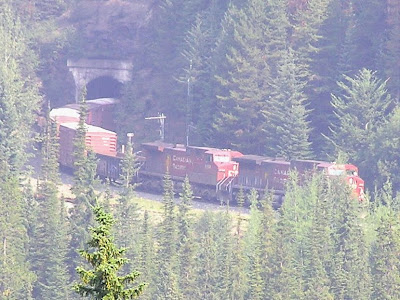
We were at the viewpoint labeled "You are Here" and watched an eastbound freight train enter the lower tunnel at Point 1 and emerge at Point 2.
Freight Cars Entering the Lower Spiral
Freight Train Emerging from the Lower Spiral Tunnel
Come to think of it, it's remarkable to note that these spiral tunnels have been in use for 100 years.

We got ourselves pointed in the right direction, went back to the Icefields Parkway (Route 93, and turned north to Bow Lake.  The Bow River has its origin with the Bow Glacier, maybe 25 miles north of Lake Louise,  The melt from the glacier tumbles down Bow Glacier Falls and out across a braided river (delta) into Bow Lake, which in turn drains into the Bow River.  (Just to the north of the lake is Bow Summit, which divides the Bow River watershed from those that flow toward the north.)
Bow Lake with Bow Glacier in the Background
We had a snack at a funky lodge on the lake.  The lodge intrigued me as the only one we'd been in that seemed to be part of the land, built to fit in the relative isolation of its setting.
Then we went out the trail toward Bow Glacier Falls, a relatively easy trail with its elevation gain concentrated on the last few hundred meters.
From Falls to River

Along the Bow Valley Parkway and Banff

The road between Lake Louise and Banff is a relatively new superhighway.  But to Canada's credit, they have preserved the old road - a very civilized two lane road - as a parkway that follows the Bow River, with viewpoints and informative signage.
The Bow Valley
We made our way into Banff, stopping for a picnic along a babbling stream (all the streams babble since the water is flowing over very rocky streambeds).  We explored the village a bit - it was crowded and seemed aggressively touristy, not a real town, but one, like Jackson, Wyoming, invented to make money off of scenery.  We couldn't help noting the different, very comfortable feeling we had in Jasper, which was a real town long before the tourists came.

We did find the natural history museum in Banff a very interesting place.
The building was built more than 100 years ago to house a collection of specimens captured and stuffed by the naturalists of the day.  Since there was no electricity in Banff, the architecture emphasized bringing natural light into the display areas.  The museum presents the collection as it might have been seen in 1914.  The taxidermists work is equisite and demonstrates how advanced the naturalists were in their identification and classification.

Our next stop was the very popular Bow Falls, just outside Banff.
Bow Falls in Banff
I imagine there are many "falls" in the Bow River, but these are particularly nice.

We finished our exploration of the southern part of Banff National Park with a drive on the Lake Minnewanka Loop, drive from Banff of perhaps 20 KM to the end of the lake.  It's a pretty drive and a large, pretty lake.  The stars of this particular show, however, were a nonchalant herd of mountain goats that stopped traffic and blocked the road for several minutes.
King of the Road


Sunday, August 22, 2010

The Tram and the Lake Agnes Trail

The wind must have changed since the air was much clearer Wednesday morning.  We went to the ski resort that lies on the other side of the Bow River Valley opposite Lake Louise.  The lift took us 3000' up in the fresh air, over bear domains - we didn't see any, but others who had gone up earlier did.  The views are great, of course.
Lake Louise from Skilift

There is an excellent visitors center at the top and some hiking trails.  The bears were active along the trails, so they unfortunately were closed.  We took the lift back down, had a good lunch, and went across the valley back to Lake Louise.

One of the things Canadian Pacific Railroad did when it was trying to attract tourists 100 years ago - oh, how attitudes toward passenger trains have changed, the CPR only carries freight now - was to build tea houses at the end of trails from Banff and Lake Louise.  We decided to hike to the tea house at Lake Agnes.  Little did we know.  Always read the fine print.  4.2 kilometers seemed innocent enough, as were the first 800 level meters.  From there on, though, the trail went up, and up, and more up - sometimes steep, sometimes steeper, only occasionally moderate - but always up.  We did our slow but steady thing and finally arrived at the teahouse, huffing and puffing - we count that as an achievement that ranks with Inspiration Point in the Tetons and the summit of Whistlers Mountain in Jasper.
Lake Agnes
  And yes, we did have refreshments at the Tea House.
Lake Agnes Tea House
On the way down - blessedly all down - we had several good views of Lake Louise.
Looking down on Lake Louise from the Lake Agnes Trail

Lake Louise, Day 1

On Tuesday, the 17th, we left the lodge we'd stayed in to go find our campsite for the next four nights - with some anticipation, since the lodge was no prize, affording only a good shower, but a lousy night's sleep.

Our campground was bear protected by an electric fence.  In spite of strange feelings about that, we were assigned a nice campsite that served us well.

There was a grand view of a mountain-top glacier through the treees from our picnic table.
After setting up the tent and a picnic lunch, we set off on a smokey afternoon, exploring first Lake Louise, with its famous Chateau at the end of the lake looking up-lake to the glacier beyond - a fabulous view that would have been even more fabulous 100 years ago before glacial warming took its toll.  The smoke from the fires in British Columbia was pretty thick and we could only guess at the Columbia Glacier at the end of the lake.

We did a short hike along the lakeshore and found some less smoke-obscured views.
Canoe on Lake Louise - Note Glacier at Upper Left Corner
Glacier in the Upper Left Corner of the Photo Above
Then we took the 10 mile drive to Moraine Lake, another lake that lies in a valley between snowclad mountains.  Still smokey, but less so than at Lake Louise.
Lake Moraine, as its name suggests, fills a valley whose sides are moraines formed by glaciers that, when they melted, dropped all manner of rocks and debris in huge piles.

Tuesday, August 17, 2010

Goodbye Jasper, Hello Icefields

On the 16th, we broke camp, had breakfast in Jasper, did some errands, and headed south on Route 93, the Icefields Parkway.

Along the way, we stopped at Athabasca Falls to finish our viewing from Friday that had been washed out by the rain.  We learn so much geology every time we step out of the Prius - we'll have to take a course so we can have context for all the bits and pieces we've learned.  We came back to the Falls because we wanted to look more closely at the channel below them. The channel is narrow and cut through closely packed sedimentary layers.  The rock must be pretty hard, because over the years a large volume of water has cut a very well defined channel that shows few signs of erosive rounding or widening.
Channel Below the Falls
One feature, called a pothole, caught our eye, a round tub-like cut in the side of the channelformed by turbulent water.
Pothole
The volume of water that goes through the channel becomes the wide Athabasca River only 200 yards beyond the Falls.  The river originates in the glaciers a few tens of miles to the south, resulting in a heavy load of suspended silt.  It is this silt that gives the rivers and lakes in the Canadian Rockies their shades of turquoise.
Athabasca River Just Below Athabasca Falls
The Athabasca River has its headwaters in the glaciers  It travels through Alberta before draining into the Peace-Athabasca Delta and Lake Athabasca on the Alberta-Saskatchewan border and thence to the Arctic Ocean via Great Slave Lake and the Mackenzie River.

Then it was down the road for 50 miles or so to the Athabasca Glacier.  This is the glacier that flows down from the Columbia Icefields to about a mile from the highway.  The Icefields, above and behind the glacier, are about 125 square miles of glacial ice as much as 1100 feet thick.  170 years ago, the glacier stretched down to the parking lot, but in receding has lost about 60% of its 1840s volume.
Athabasca Glacier Seen From the Icefields Visitors Center
Looking across the Athabasca Glacier toward the Columbia Icefields
We went about two-thirds of the way up the glacier on wonderful big buses, with 30 minutes actually on the glacier - much closer views of the steps in the glacier (where the glacier flows over especially hard rock) and the lip of the Columbia Icefields.
 Just to show we both were there
An unexpected delight were the views from our glacial bus stop of the Andromeda Glacier. That glacier has carved a huge cirque into its mountain.
Andromeda Glacier
One should spend as much time in the visitors center as on the tour in order to comprehend the magnitude of the Athabasca Glacier and the Columbia Icefields that feed it.
Mt. Athabasca from the Visitors Center
Finally, we left the Icefields and drove to Lake Louise, coming through thicker and thicker haze.  We are told that there are very bad forest fires in central British Columbia and the smoke has drifted through the passes.  The fires are a long way from containment, and we wonder how much of the mountains in Banff National Park we'll be able to see.

A Last Day at Jasper

Sunday morning we had a lazy breakfast (there's not much action in Wapiti Campground until 9:00 or later) and then went into Jasper for the 10:30 service at the Anglican Church.  Good people, a congregation smaller than Shepherd by the Sea's, with a Mexican priest coming as Vicar.  It was nice to see people whom we'd met the evening before.

In the afternoon, which was hot, and more humid than we were used to, we did a relatively short hike - Whistlers took a lot out of us - up the Maligne River Canyon, just above Jasper.  It's a lovely hike, much of it in the trees.  Lots of falls and rapids. 
And some places where underground streams (from Lake Medicine?) emptied into the river.
It was spitting rain at the end of the hike, but we decided to revisit Pyramid Lake, on the other side of Jasper.  The rain had stopped so we did some exploring.  There's a bridge to an island 100' or so from shore.  The island is a community park, apparently a favorite for romance.  Walking out, we encountered a wedding party - we surmised that the wedding had happened probably at the the lodge down the road, that the party came to the island for pictures, and that they were returning to the lodge for dinner.  As we walked around the island, we found peaceful views in abundance.
Pyramid Lake Reflections
And then back to Jasper, supper at L&W Restaurant, our favorite, a walk to the other end of town for an ice cream cone, and then back to Wapiti Campground to prepare for our move to Lake Louise.

SUN! and Whistlers

The weather changed dramatically overnight.  Saturday was clear and sunny and wonderful.  We had breakfast and immediately went to see the top of the world.

Jasper is surrounded by mountains.  One of those is Whistlers, named for the sounds made by the resident marmots.  Whistlers sits about 4000' above Jasper.  One can climb to the summit - for 4-6 hours (multiply by two for us old fudds) on a developed trail.  Or, more practically, one can go up most of the way on a tram and hike the remaining 700' of elevation.

Looking down to the Tram (left), the Trail to the Summit (center), and Jasper (far right)
For the old fudds, the hike of a mile or so to the summit is a challenge, but well worth it.  Views in all direction, views not accessible down below.  The valley to the northeast leading to Hinton and Edmonton, the Yellowhead Valley leading west into British Columbia, the Athabasca Valley leading south.  Edith in regal dress.
Looking South to Mt. Edith Cavell
Mt. Robson is a snow-covered pyramid glistening in the distance.  Mt. Robson is 12,972', and although the highest peak in the Canadian Rockies, not the highest mountain in Canada, that honor belonging to mountains in the Coast Range.
Mt. Robson
Snow-capped mountain ranges behind the close-up ranges. The mountains of Jasper and Banff are three dimensional - not a single line of mountains like the Tetons, but an area filled with mountain ranges beyond mountain ranges beyond mountain ranges.
Joan on Top of Whistlers
Joan befriended Emma, a nine year-old who had visions of dying, or worse, before she got to the summit.  Of course, Emma got to the summit first.
Joan and Emma
We spent most of the day on top of Whistlers, drinking in God's abundance.  We found we could see south into the Athabasca Valley.
Athabasca Valley with the River and Route 93
We also found that we could see Wapiti Campground and almost see our campsite, even if the orange tent fly didn't show up.
Wapiti Campground between the Highway and the River - our Campsite is Right of the Clearing for RVs
We had a nibble at the Tram Station, went down on the Tram, and drove into Jasper, where we found that the Rocky Mountaineer, a luxury excursion train, had arrived.  And the train from Jasper to Prince Rupert was made up and ready to go.
Rocky Mountaineer
Train to Prince Rupert
That evening, we stopped by the Anglican Church in Jasper.  They were holding an art auction as a fund-raiser and had some fine pieces - Jasper attracts good artists.  The pieces were too large to fit into the Prius, so we enjoyed without bidding.